Monday, January 31, 2011

Dunedin, New Zealand

Our first stop in Dunedin was at Baldwin Street, the steepest street in the world (according to the Guiness Book of World Records).


We all managed to walk up it! We treated our efforts with a tour of the Cadbury factory in town.

We spent quite a bit of time out at the end of the Otago Peninsula. At Pilots Beach, we saw New Zealand fur seals.


The highlight of Pilots Beach is the arrival of the blue penguins at dusk. We sat (or stood in the back) and watched as the tiny penguins came ashore to feed their young. They don't grow taller than 30 cm, and are easily startled (if you make sudden movements or talk, they won't come near you). I was fortunate to have several come up to me. I didn't want to startle them any more than I had to, so I didn't take pictures. But before it got too dark, I did take a picture of a baby waiting in its nest.


The next day, we toured the local Speight's Brewery.


I also took a picture of the "most photographed building in New Zealand", the Dunedin train station.


On our way out to the end of Otago Peninsula (for a second time), we stopped for a hike at (above, we never went all the way down) Tunnel Beach. I think Tunnel Beach gets its name from the arch in the rock.


The reason we went out to Otago Peninsula for the second straight day (despite the windy roads) was to see an albatross nesting site. This is the only mainland nesting site in the world.


I'm currently sitting in the Sydney airport, so I'll wrap up my New Zealand trip once I get home!

The Catlins, New Zealand

On our way from Te Anau to Dunedin, we decided to travel to Invercargill (on the south coast of the island), then along the coast through an area known as the Catlins.

Our first stop was in Fortrose, where we saw an old shipwreck poking out of the water. Further along the coast, we took a little hike to a lighthouse. Our next stop was Cathedral Caves, accesible for only two hours before or after low tide, the two caves were about 100 feet deep and connected in the back. I took this picture on my way out of the second cave.


Fortunately, low tide occurred in the afternoon, which fit nicely with our travel schedule!

Then we went to Nugget Point. There was a path above steep cliffs out to a lighthouse, with some interesting rock formation in the water.


Nearby Nugget Point was Roaring Bay, which had a penguin hide for watching yellow-eyed penguins come ashore. By this time of year, both parents fish during the day, then come back to the nest in the late afternoon to feed their young.


That night, we stayed in Balclutha.

Saturday, January 29, 2011

Te Anau and Milford Sound, New Zealand

Te Anau is a small village on a big lake on the edge of Fiordland. Our first day there, we checked out a small bird conservation area, where we saw some kea (an alpine parrot),


and an Antipodes Island parakeet.


In the late afternoon, we took a boat across Lake Te Anau


to visit a cave with glowworms. Cameras weren't allowed, so I don't have any pictures. It was pretty amazing, though, like a planetarium in a cave!

The next day, we drove to Milford Sound. Unfortunately, it was cloudy and rainy. Fortunately, although we missed out on some great views, we did see hundreds, if not thousands, of waterfalls.


In the sound (which is actually a fjord), we saw a family of dusky dolphins feeding.


I think this was Mitre Peak, which is the most famous mountain in the area.


Here is a sunnier picture of it.

We also saw New Zealand fur seals on some rocks.


We finished the tour around the sound (fjord) passing Lady Bowen falls.


(Compare my picture with Wikipedia's to see what a difference the rain made!)

It finally stopped raining once we got back to Te Anau, where we had a nice sunset.

Monday, January 24, 2011

Queenstown, New Zealand

Sunday morning we travelled from Franz Joseph glacier to Queenstown. We drove down the coast, past Knights Point,


then headed inland. We saw several waterfalls, including Thunder Creek falls:


We also saw Fantail Falls, which seemed to have the most cairns in one place that I've ever seen!


We left the rainforest plants behind as we headed into Haast Pass.


The inland lakes here have some of the bluest water I've seen. Like Lake Wanaka:


We passed through the Central Otago wine region


then into Queenstown.


Queenstown is located on Lake Wakatipu, which impressed with its blue waters and the nearby Remarkables.

The TSS Earnslaw (TSS stands for Twin Screw Steamship) is a coal-fired steamship that chugs its way constantly between Queenstown and Walter Peak farm.


Our hotel had a nice view of the lake, and I took this picture of Queenstown at sunset.


The next day, we took a gondola up a nearby mountain.


Terri and I did some luging in little carts at the top (but no bungy jumping!). In the afternoon, we went over to Walter Peak on the TSS Earnslaw. The farm there has alpaca (I caught this one yawning!)


red deer (I'm surprised at how many deer farms there've been in New Zealand)


and sheep. We had afternoon tea, then saw a demonstration of an Australian Shepherd at work,


and sheep shearing. We boated back to Queenstown for a nice dinner. The next morning, we headed for Te Anau.

Franz Joseph Glacier, New Zealand

It was cloudy on the east side of the island when we left Christchurch and headed into the mountains.


Fortunately, it was sunnier on the west side.


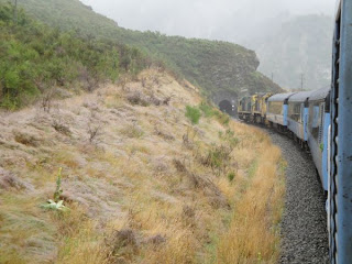
We arrived in Greymouth, rented a car, then drove down the coast to the town of Franz Joseph Glacier (near the 
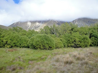
glacier of the same name). The west coast is an interesting combination of rain forest and mountains.

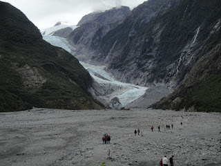
The next day, we hiked up to the Franz Joseph glacier.


That afternoon, we checked out the West Coast Wildlife Centre, where kiwi conservation efforts are underway. There are several species of kiwi in New Zealand, all of them endangered to some degree, because there were no predators (mammals) of any kind until westerners brought them. The local species, the Rowi kiwi, is the most endangered. Their main predator is the stoat, originally brought to the island to keep the rabbit population under control. Apparently, a newly hatched Rowi kiwi has a 5% chance of surviving to adulthood, but at the center, they have an 85% chance. Since there are only about 375 of them left, it makes a big difference! The kiwi grows to almost the size of a chicken, and once it reaches about a kilogram, it can defend itself with the claws on its feet. The Centre incubates eggs until they hatch, then keep the baby kiwis for a few months. Then they are sent to a predator-free island between the North and South Islands of New Zealand, where they learn to hunt for themselves (they eat mostly grubs from the soil). Then they are brought back to the area and released into the wild.

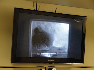
Anyway, we were lucky because when we got there, they had a kiwi that had hatched the previous day. I took a picture of the monitor that showed a live video feed of the kiwi.


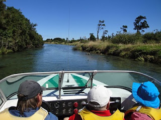
The next day, we went to a White Heron sanctuary. It's the only place on the entire island where the birds nest. To get there, we took a "jet boat" ride down a glacial river then up a rain forest river.
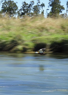
Here, a paradise duck plays with the boat by flying in front of it.


Here's a picture of one before it was able to get in front of us!


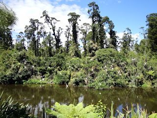
The White Heron nesting site was not very big. This picture pretty much shows the entire area.


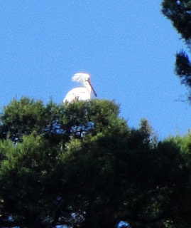
Also nesting in or around the area were shags (cormorants)


and spoonbills (they tended to nest higher up in trees, and my camera only had so much zoom!)


That evening, we travelled south to Fox Glacier.


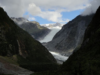
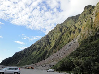
We also got a little closer


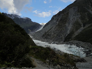
but the trails here were closed due to problems with rock slides.


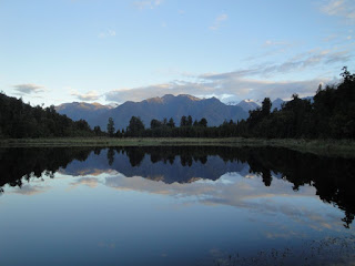
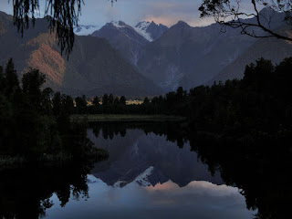
We had dinner at the Lake Matheson cafe, then hiked quickly around Lake Matheson to catch the sunset. These are some mountains near Fox Glacier.


And here are some trees I liked.


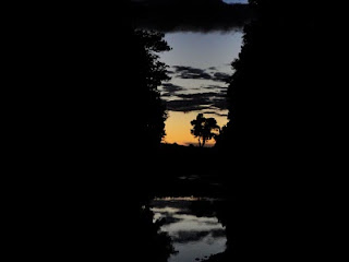
While heading back to the cafe, we crossed this stream, which led west to the sea. It allowed us to see the last light of the sunset.


The next morning, we left for Queenstown.